

GeoNet have published their latest future scenarios and aftershock forecasts following the M7.8 quake that struck early on Monday morning. Their advice follows …
To help understand the earthquakes and what to do about them, many people what to know what will happen next? While we can’t predict earthquakes we can provide some forecasts of future aftershocks and possible scenarios.
Probabilities have been calculated and scenarios have been developed and presented over the past few days. With our current information the most likely scenario (Scenario 1: Extremely likely: >99% probability within the next 30 days) is that aftershocks will continue to decrease in frequency over time. We describe this scenario below, along with two other scenarios that have lower probabilities of occurring alongside Scenario 1.
General information about the probabilities and scenarios
Most earthquake aftershock sequences decay over time, with spikes of activity and occasional larger earthquakes. Based on the revision of the earthquake to M7.8 we have updated our probabilities of similar or larger sized earthquakes; we use probabilities as we cannot predict earthquakes. The probabilities in the table below describe the likely progression of the sequence within the next day, week and month. The scenarios specifically address what we expect within the next 30 days, however, we expect aftershocks to continue for months to years.
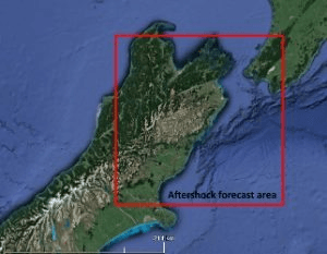
Within this sequence, aftershocks will most likely occur anywhere in the box on the map below. It is this geographical region for which the modelling is done. It is important to understand that earthquakes can and do happen outside this box but the box represents the most likely area related to this sequence.
Forecast for rectangular box with the coordinates -40.7, 171.7, -43.5, 171.7, -43.5, 175.5, -40.7, 175.5 at 12 noon, Friday 18thNovember. * 95% confidence bounds.
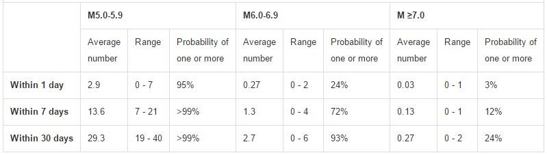
For example, there is a 24% chance of one or more M6.0-6.9 earthquakes occurring within the next day. We estimate there will be between 0 and 2 earthquakes in this magnitude range within the next day. The current rate of M6 and above for the next month is about 100 times larger than what we would normally expect for long term seismicity represented in our National Seismic Hazard model. As the aftershock rates decrease, this difference will decrease as well.
Scenarios
There are very different probabilities for each scenario; some of these may be more unsettling to you than others. We recognise that while these scenarios may increase anxiety the best thing is to be prepared. Remember: To drop, cover and hold in an earthquake. If you feel a long or strong earthquake and you are on the coast, evacuate immediately.
Scenario One: Extremely likely (>99% within the next 30 days)
The most likely scenario is that aftershocks will continue to decrease in frequency (and in line with forecasts) over the next 30 days. Felt aftershocks (e.g. over M5) would occur from the M7.8 epicentre near Culverden, right up along the Kaikoura coastline to the Cape Palliser/Wellington area. This includes the potential for aftershocks of between 6.0 and 6.9 (93% within the next 30 days). Scenario one will continue to play out, even if either scenario two or three also occurs.
Scenario Two: Unlikely (approximately 25% within the next 30 days)
An earthquake smaller than Monday’s mainshock and between M7.0 to M7.8 would occur. There are numerous mapped faults in the Marlborough or Cook Strait areas capable of such an earthquake. It may also occur on an unmapped fault. This earthquake may be onshore or offshore but close enough to cause severe shaking on land. This scenario includes the possibility of an earthquake in the Hikurangi Subduction Zone. Earthquakes here or in the Cook Strait have the potential to generate localised tsunami. The Hawke’s Bay earthquake sequence in 1931 provides an analogy to scenario two, as a M7.3 aftershock occurred approximately 2 weeks after the initial M7.8 earthquake.
Scenario Three: Extremely unlikely (<1% within the next 30 days)
A much less likely scenario than the previous two scenarios is that recent earthquake activity will trigger an earthquake larger than Monday’s M7.8 mainshock. This includes the possibility for an earthquake of greater than M8.0, which could be on the ‘plate interface’ (where the Pacific Plate meets the Australian Plate). Although it is still very unlikely, the chances of this occurring have increased since before the M7.8 earthquake.
Other hazards
The earthquake activity has caused tsunami and landslides. As a reminder, if an earthquake is too strong to stand up in, or lasts longer than a minute, move inland or to a higher point immediately; don’t wait for a siren or further information.
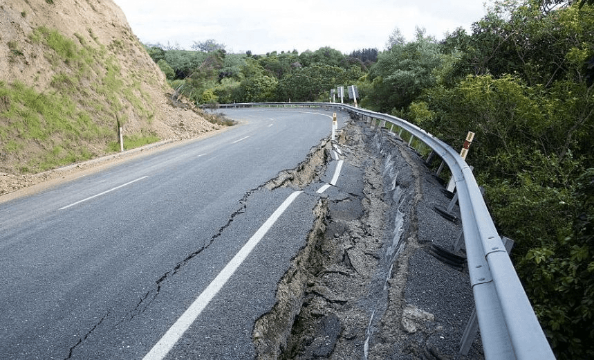
Extensive landslides have occurred as a result of the earthquake, and these remain dangerous. Material can move at any time. Please exercise caution when in the vicinity of landslides and cracks in the ground on slopes. If it is raining, the threat rises as the water can remobilise the landslide material as debris flows and debris floods (flash floods). Landslides have also dammed rivers, which can breach, particularly after rainfall. Please avoid landslides in wet weather, and rivers downstream of dams.
For more information please go to GeoNet. For support, try the The All Right website or hotline (0800-777-846)