

Auckland’s false ‘felt’ reports on GeoNet aren’t necessarily the work of an evil mastermind – usually, it’s someone bored, confused or trying to make some art.
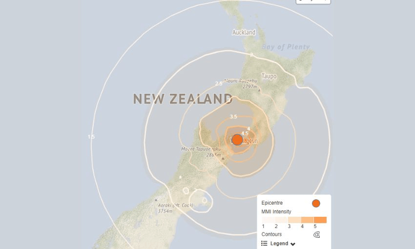
On Sunday, a magnitude 5.7 earthquake struck 25km west of Wellington, forcing new-to-town uni students out of their beds while hardened locals spread snore-induced aftershocks. For the unbridled patriots, data obsessives and light sleepers, there was only one place to go now: our nation’s hazards monitor, GeoNet.
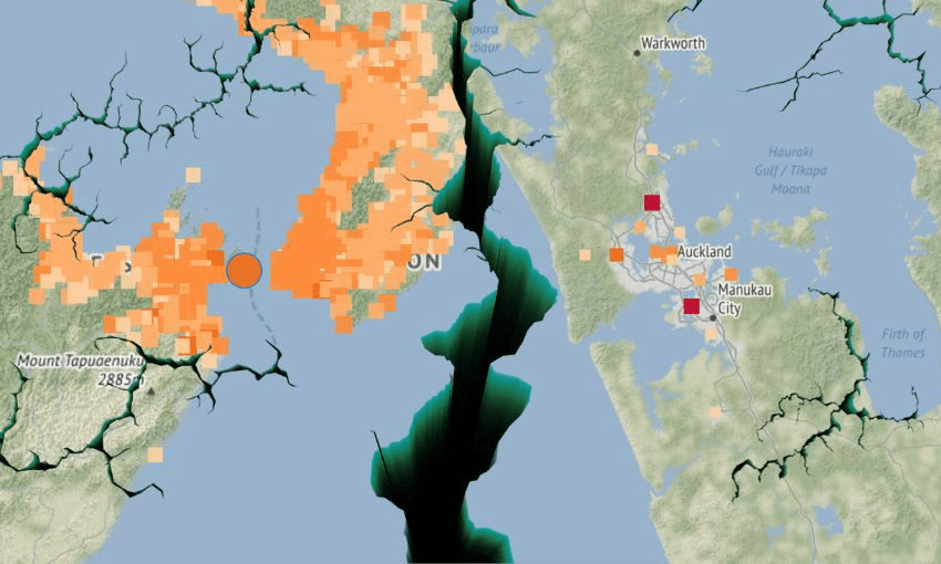
Though the quake was only moderate by seismic standards, a lone wolf in Auckland’s North Shore, about 515km from where it hit in the centre of the Cook Strait, marked an extreme shake on GeoNet. Smattered around the central, west, south and east areas of Auckland, others also reckoned they felt something “strong” or at least “moderate”.
It would be funny, if Aucklanders didn’t already have a reputation for ruining the sanctity of GeoNet’s felt maps, designed to show how widely and strongly quakes are felt so GeoNet can develop a response for the public. Check the significant quakes from the past year through GeoNet’s archives, and you’ll find Aucklanders popping up in all areas of the Super City claiming they’ve been shook by a Wellington or South Island quake no matter its magnitude.
Without fail, Auckland in with the extreme rating. Never change. pic.twitter.com/sq2IUs5iqZ
— littledogleftabighole (@mrmondaynz) October 5, 2024
The GeoNet felt report map is a thing of beauty to the data-obsessed mind. Those (sometimes thousands) of dots represent the hardened New Zealanders who know how to correctly respond to an earthquake: drop, cover, hold, open the GeoNet website, submit felt report. Most New Zealanders can be trusted to mark themselves accordingly on GeoNet, but some are more unruly, or just confused.
GeoNet’s geohazards information specialist Sara Horne says they’ve been dealing with rogue felt reports for years, some for quakes which never even happened. Horne chalks these fake quakes to three possibilities: people who are bored, people who have accidentally submitted their correct suburb in the wrong city, and people using a VPN.
“We also get people occasionally submitting multiple extreme reports around the country, trying to make pictures on the map of NZ on our home screen,” Horne said. Luckily for GeoNet, there is a time limit on the felt report map, meaning some reports “time out” and don’t stick around. “But there was one instance where you could tell they were definitely aiming for a … certain appendage.”
To curb this, the monitoring entity last year introduced a “shaking layers” map alongside its felt report map to show the median shaking in an area. The map provides “the combined recorded data from strong motion stations with ground motion models to produce spatial estimates of ground shaking for each intensity measure”, according to Horne.
Measured in Modified Mercalli Intensity (MMI), which estimates shaking intensity and its effects on a given location, the shaking layer map from Sunday’s magnitude 5.7 quake shows shaking registered less than magnitude 2 between upper Waikato and Northland, meaning there’s no way it could have felt “extreme” in Auckland.
“While this doesn’t help with solo reports, it makes them less significant compared to other surrounding truthful reporting,” Horne said. “It’s easy to see, when looking at a felt map for a particular earthquake, the ‘false’ reports [are] far from the earthquake’s epicentre, so we just ignore them.”
So, what happens to all those felt reports?
Felt reports give GeoNet an idea of how strong and spread a quake was, though significantly more New Zealanders check the reports than submit their own. Some users submit “felt detailed reports”, a survey of 40 questions designed to understand someone’s personal experience and response to a quake.
Civil Defence also uses GeoNet’s felt reports in the first few minutes following an earthquake when more information isn’t immediately available. The reports help Civil Defence decide their next steps in responding to a disaster, and signals where communication and power outages could be occurring (following the 2016 Kaikōura quake, the lack of felt reports from Kaikōura itself signalled outages).
Detailed felt reports are used by GNS Science and other researchers to monitor earthquake responses (as in, how many people stopped, dropped and held) and tsunami evacuation rates. By 2020, GeoNet had amassed a database of 17,000 tsunami-related detailed felt reports, making it the biggest dataset of its kind globally.
All of this is to say, if you really wanted to mess with GeoNet’s data tracking, you’d take the time to fill out the four-minute detailed felt report. And then mark yourself as an Aucklander.