


A newly released map reveals the extraordinary complexity of Monday morning’s monster magnitude-7.8 earthquake. GNS Science earthquake geologist Nicola Litchfield explains what we’re looking at. Below, Ursula Cochran explains the big picture.
Following the Kaikoura earthquake early on Monday morning, GNS Science geologists Nicola Litchfield and Pilar Villamor flew south by chopper from Wellington to make the first, visual observations of which fault lines had ruptured.
Their findings are recorded in this map; below Nicola Litchfield explains what it tells us.
The Spinoff: What is this map telling us?
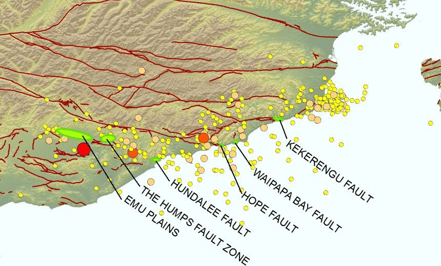
Nicola Litchfield, GNS Science: The map at the moment is showing where the aftershocks are, and the green circles, or ovals, are showing places where we observed fault rupture, when we flew in a helicopter on Monday. We saw, as you can see, multiple fault ruptures.
To be clear, that’s six faults that have ruptured?
At least. On our initial flight we only flew down the coast and straight to the epicentre area and there are some flights going on today, inland, and I think we’ll find more faults inland.
We certainly saw some faults going offshore. So the Hundalee fault and the Kekerengu fault, and actually the Waipapa Bay and the Hope fault – all of the faults along the coast, we definitely saw from the flight going across the beach and heading offshore. So they’ll be the ones that caused the tsunami. There’s also a lot of coastal uplift along the coast. You’ve probably heard, there’s paua and crayfish and things out of the water. So we’re trying to measure that as well. The question is: are there some more faults offshore that we don’t know about, either. People from Niwa will be looking into that as well.
So the ones on the coast that are marked on the map, we don’t know how far into the sea they go?
No, not at all yet. There are a lots of faults mapped offshore, but the question is did all of the fault rupture or just a part of it in this earthquake, because we’re only seeing in some faults, only part of them ruptured onshore. So hopefully we’ll get some more data on that eventually from offshore surveys.
This is more than you presumably would have expected to see when you set off? That’s a lot of faults.
Yes. Usually you expect one big earthquake on one big fault, but like in the Christchurch earthquakes, and in fact we saw this in Edgecumbe in 1987, we often get these complex ruptures, where multiple faults rupture in the one earthquake. But this was a bit of a surprise, as to how many and which ones have ruptured.
Does the number of faults make it more difficult to project aftershocks and outcomes?
It’s harder to make the models, as to what happened in the earthquake and therefore what is going to happen in the future. That’s really for the seismologists, but it does make it take longer to understand what’s happened.
Do we know which one went first?
The earthquake started in the south. So the big red dot, the M7.5 [since upgraded to 7.8], that’s the epicentre of the first earthquake, so we’re pretty certain that the faults just to the north of that – the Emu Plains, the Humps fault, the Hundalee fault – went first, then it continued up the coast, up to, a little bit on the Hope fault but particularly the Waipapa Bay and the Kekerengu fault went second. I certainly felt that in Wellington: when I woke up I felt two parts to the earthquake, and we think that’s what happened, we had a southern part and then a more northern part.
So they happened more or less instantaneously?
Yes. Most people would have considered that all part of the same earthquake. I think the first part, the southern part, was about 30 seconds, and then followed immediately afterwards by the ruptures up to the north. Most people would consider that just one big long earthquake.
Does each one of those ruptures cause its own aftershocks?
Yes, you can see the cloud of aftershocks that have happened and they’ll be focused around all those faults.
See also: When the seaflooor surges out of the ocean – coastal uplift explained
Does that explain why there have been more aftershocks than there were after Christchurch?
This is a much bigger earthquake, a magnitude-7.5, whereas the first Christchurch earthquake [in September 2010] was a 7.1. And then the February one was only a 6.2. So part of the reason we’re getting more aftershocks is that it’s just a much bigger earthquake.
Have we seen anything with this many faults before, though, in recent history?
Certainly not in New Zealand. I’m not sure about overseas: there have been complex fault ruptures but I don’t know that we’ve seen this many in an earthquake overseas.
So for the scientists, for GNS, this is – I suppose exciting is not the right word – but it must be fascinating.
When people die in an earthquake it is never exciting. But scientifically it is a very interesting earthquake, that’s for sure.
The fault pattern
Ursula Cochran, earthquake geologist at GNS Science, writes …
The big picture
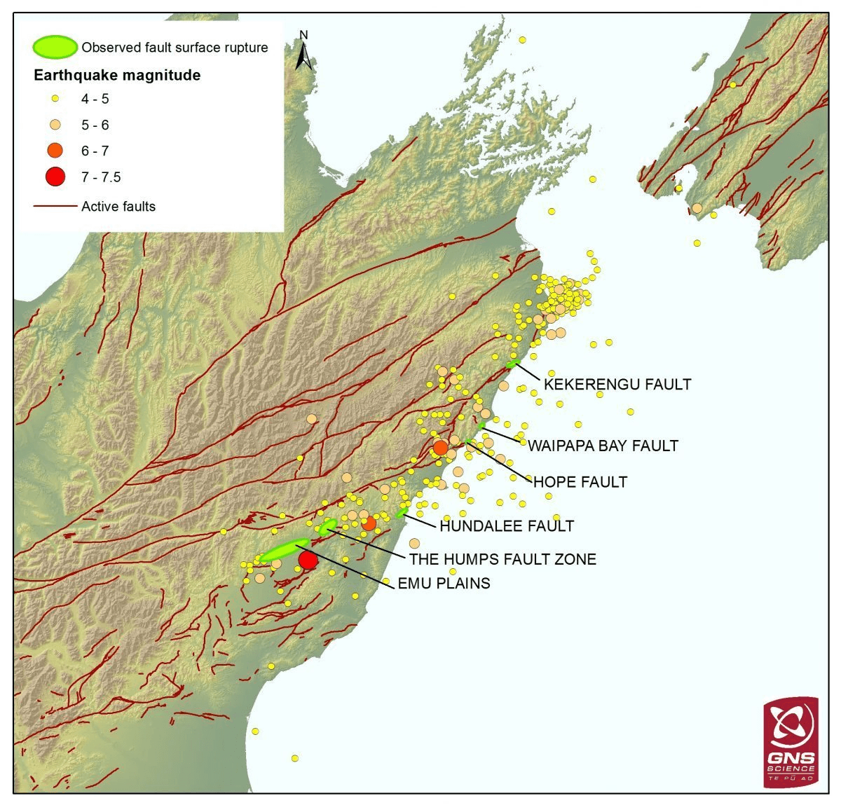
In the northeast corner of the South Island many active faults spread across the landscape from the Alpine Fault in the west to the Hikurangi subduction zone in the east. This region is so broken by faults because it marks the location of a major change in the type of movement between New Zealand’s two tectonic plates.
In the central South Island, the Australian and Pacific tectonic plates are sliding past each other along the Alpine Fault but offshore of the east coast of the North Island the Pacific plate is diving down beneath the Australian plate along the Hikurangi subduction zone. The faults in North Canterbury and Marlborough represent the shearing and breaking of the earth’s crust that happens when tectonic plates change from sliding past each other to colliding head-on.
The Kaikoura earthquake
Commonly large earthquakes break a single fault in the earth’s crust and aftershocks occur in a focused area around that fault as the crust adjusts to the movement. Monday’s event was much more complicated. The location of aftershocks and field observations of where the crust has broken (see map) indicate that earthquakes occurred on more than one fault.
Already, it looks as though parts of well-known faults such as the Hundalee, Hope and Kekerengu Faults have ruptured (broken) and also parts of less well-known or unknown faults around Emu Plains, The Humps Fault zone and Waipapa Bay have also ruptured. Such a sequence of earthquakes occurring on different faults in such a short time-frame has not been witnessed before in New Zealand. There will be many types of data and days of collection and analysis required to make sense of what happened and what the implications of this earthquake sequence are for the future.
The Spinoff’s science content is made possible thanks to the support of The MacDiarmid Institute for Advanced Materials and Nanotechnology, a national institute devoted to scientific research.