
The naturally occurring weather event has been officially declared. Madeleine Chapman explains what that means in today’s excerpt from The Bulletin.
To receive The Bulletin in full each weekday, sign up here.
Every few years, scientists and science journalists pick a day to patiently explain the El Niño weather phenomenon to us, and every time we mostly understand. That day was yesterday, as Earth Sciences New Zealand (ESNZ) officially declared El Niño a weather event here, reports Kate Newton for RNZ.
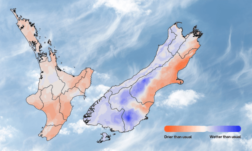
In short, El Niño is a naturally-occurring phenomenon when trade winds (east-to-west) weaken, leading to unusually warm water in the eastern Pacific and cooler water in the far western Pacific. During El Niño, New Zealand is likely to experience stronger and more frequent winds from the west in summer, leading to dryness in the eastern parts of the country and more rain in the west.
A super El Niño and cause for concern
Speaking to Toby Manhire on the At Large podcast, ESNZ’s Jon Tunster said New Zealand is “well on track” to experience a “strong” El Niño, with sea surface temperature readings in the east-central tropical Pacific, where El Niño originates, already 1°C above average (at 1.5°C it becomes a “strong” El Niño). But Tunster anticipates even more increases, potentially to 2ºC, or a “super” El Niño.
How strong exactly? In comparing this year’s to the five strongest El Niño events in New Zealand history (1972, 1982, 1991, 1997 and 2015), principal scientist Chris Brandolino said “there are compelling reasons to believe it will exceed that, and it has all the makings to be an historically strong event.”
ESNZ’s forecasting suggests stronger winds and dry days for the east coasts during spring, bringing with it heightened risk of drought and wildfires heading into summer. This will be of particular concern for places like Christchurch, which just recorded its driest May on record, reports The Press (paywalled).
In The Conversation in May, three scientists argued New Zealand has underestimated its vulnerability, both environmentally and economically, to big droughts. ”Droughts far more severe than those experienced in recent memory already exist within New Zealand’s climate history. Yet many modern risk assessments still rely heavily on relatively recent events, potentially underestimating the true scale of drought variability the country is capable of experiencing.”
One such “forgotten big dry” was in the summer of 1914-15, also during El Niño. But University of Waikato climate scientist Luke Harrington stressed to RNZ (Newton again) that not every El Niño brings a drought and not every drought happens during El Niño.
Is Europe’s melting summer headed here?
Not quite. While some local reports this week have attributed Europe’s record-breaking temperatures of late to El Niño, the World Weather Attribution (WWA) consortium analysed the heatwaves, particularly in relation to climate change impacts, and ruled out any influence from El Niño, reported the Guardian last week. Instead, WWA scientists said the high pressure system creating a heat dome over Europe is not unusual, but global warming has exacerbated it severely this year.
However, record-breaking temperatures in Europe and around the world, along with a warming Pacific ocean and unseasonably warm days already this winter, suggests New Zealand may see some very hot days this year. “Perhaps not 40°C or 44°C like we’ve seen in Europe, but certainly that spikiness is something we’re expecting,” said Brandolino.
This is going to ruin the tour school holidays
While ESNZ’s forecasting for El Niño is largely focussed on spring impacts, they’ve noted a “significant rain event within the first 10 days of July” likely to impact places like Canterbury and Marlborough. But while it may dampen some school holiday plans, the rain is good, says Brandolino. “Were it not for this expected rain event for parts of the eastern South Island, boy, they would be in some real dire straits.”
But Tunster advises against setting your watch to this week’s El Niño forecasts either way. “Here are the broader El Niño impacts we expect on the country but there’s still such a thing as weather inbetween all that.”