
It started in Alaska, with a grizzly bear sketched in coloured pencil. Three years and 1,641 species later, Anton Thomas’s Wild World map is finally complete.
This is an excerpt from our weekly environmental newsletter Future Proof, brought to you by AMP. Sign up here.
Stuck at home during a pandemic lockdown, artist-cartographer Anton Thomas, like many of us, was desperate to escape. “I thought: this is my chance. I’m going to make that world map that I’ve always dreamed of,” he says.
From his home in Melbourne, Thomas began his artistic expedition in Alaska, sketching out a grizzly bear with a mouthful of salmon in coloured pencil. Three years later, Wild World was finished: 1,642 animal species depicted across land and seascapes in an intricate and expansive world map. Thomas had three criteria for choosing species to illustrate: they had to be wild (“No domesticated animals. No French bulldogs,” he says), as well as native and currently living.
“It’s a celebration of the nature that we still have,” says Thomas. “There is plenty of very bad news to look at about the ecology of this planet. But I want people – especially the next generation – to know that there’s still so much wilderness on this planet. There’s so much to protect.”

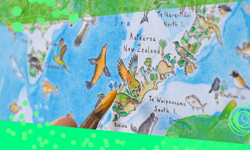
In New Zealand, a tūī towers next to Mt Taranaki, a black robin perches on the Chatham Islands, and a longfin eel swims towards its breeding grounds near Tonga.
Thomas grew up in Nelson, where the nearby mountains and ocean sparked geographical curiosity. He has loved maps for as long as he can remember. “People often get excited at fantasy world maps, but maps of the real world gave me the context that I needed to understand that I was already in a fantasy world of epic proportions,” he says.
Going on the Wild World expedition allowed Thomas to discover nature in far-flung places: “surreal looking” monkeys in the Amazon, and “spooky” deep-sea fishes. “There’s one called the giant oarfish and it literally looks like a giant sea serpent,” he says. All the weird and wonderful species inhabiting the map are listed in an accompanying booklet.
The map itself foregoes political borders, roads and cities to focus on what Thomas calls the “foundational layer” of nature. “Mountains, deserts, forests, ice, ocean and millions of species – of which we are but one. It’s a map of nature, rather than nations.” Labelled geographical features make the map not just an artwork, but a resource. This is part of Thomas’ philosophy: using art to draw people in, “but it’s like a Trojan horse: nested inside is the geography lesson.”
In the age of smartphones, where an app does the work of navigating maps for us, Thomas wonders if we’re “losing our geographic foundations, our sense of place.”
“I think there’s a massive opportunity for cartographers to provide beautiful, informative, creative maps. So people can keep figuring out where they are.”