spinofflive
Rush hour at the business end of Murrays Bay wharf. (Photo: Andrea James)

SocietyFebruary 9, 2024

Murrays Bay wharf is Auckland’s best bombing spot

Rush hour at the business end of Murrays Bay wharf. (Photo: Andrea James)

Locals have been jumping off this North Shore wharf for generations. A 2016 rebuild made the whole experience even more fun.

Photos by Andrea James.

There’s probably a good reason for Murrays Bay wharf.

When it was first built in 1916, the wharf at Murrays Bay was one of only a handful on Auckland’s North Shore, making the East Coast Bays accessible to holiday makers and day trippers arriving by ferry. Takapuna and Browns Bay also had wharfs, but they’ve long since gone, replaced by the Auckland Harbour Bridge and its cars. Now Murrays Bay wharf is the only deep(ish) water wharf between Devonport and Whangaparaoa, a stretch of more than 20 kilometres.

I don’t know whether it’s because this wharf is the only place where you can load or unload a decent sized boat (therefore forming part of an emergency response plan) or whether Murrays Bay’s topography makes it the only sensible place for a wharf to be retained. Either way, whereas other local wharves have long since been removed, Murrays Bay wharf has been rebuilt, twice.

Anyone who’s been to Murrays Bay in the summer knows that the wharf is no longer used by boats. Even the Murrays Bay Sailing Club doesn’t use it. It was the last rebuild, coinciding with the centenary of its construction in 2016, that provides a clue as to the wharf’s true value, and why it’s still there.

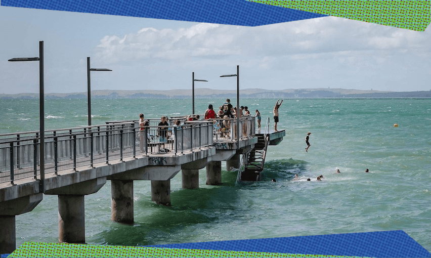
The wharf is 60 metres long, and at high tide it sits about three metres above approximately three metres of water. An ideal spot, in other words, for executing the perfect manu.

On a busy summer’s day, when high tide’s somewhere in the middle of the day, hundreds of people make their way to Murrays Bay wharf, squeeze past the fishermen, and jump off. Those who jump are an amazing cross section of society – all shapes, sizes, ages and colours. The wharf’s wooden steps, ostensibly for boat access, mainly operate one way, enabling jumpers to make their way back up for another manu. And another.

Murrays Bay wharf is a piece of social infrastructure. High enough to be scary, safe enough to be encouraging. Leaping from the wharf is challenging, but also potentially hours of fun. Climbing onto the timber handrail, adding another metre of height to your jump, adds another level of challenge. Climbing the lampposts for an extra three metres is possible, but not exactly recommended. The brief installation of a trampoline last year was a step too far, at least according to the concerned members of the local Facebook group who swiftly got it removed.

When the wharf was rebuilt, at a cost of $16m, it was an acknowledgement not just of its historic value, but also its contemporary importance to the entire Murrays Bay community. It was made wider, creating more space for more people. Filleting boards were added to keep the walkway clean of fish. Seats were provided, as was a ladder.

Most importantly, in a flagrant rebuke to health and safety over-anxiety, the final few metres were kept clear of handrails, creating a broad platform designed for jumping. The deck of this platform is timber, easier on bare feet. It’s wide enough that you and your friends can stand at the edge, but there’s also enough room to stand safely away from it. While it must have been tempting to load this end of the wharf with safety features and restraints, instead they were removed, ultimately making it a safer place for people to do what they were going to do anyway.

Murrays Bay wharf isn’t an essential piece of Auckland infrastructure. It embodies a generosity of spirit that all public buildings should have. It’s a structure that goes beyond its pragmatic purpose to bring joy to our lives.

For Year 6 graduates of the local primary school, “wharf jump” is a rite of passage. The wharf at Murrays Bay is a place where boundaries are pushed, kids grow up, and memories are made. It’s a place that brings the community together, and that’s reason enough for it to exist.

Mat Brown is an architect, design manager and co-host of 76 Small Rooms, a podcast about Architecture in New Zealand.

Photo: Andrea James
Keep going!
a jar with a tick or a cross and a watery background
Should I swim here? (Image: Tina Tiller)

SocietyFebruary 9, 2024

A trip to the beach with the poo detectives

a jar with a tick or a cross and a watery background
Should I swim here? (Image: Tina Tiller)

In recent years, checking online for a green tick has become a necessary habit for Aucklanders heading to the beach. Shanti Mathias tags along with the team tasked with testing the water for pollution – and figuring out how to stop it. 

“We get to be poo detectives,” Stephen Ashley says. This is how the water quality specialist at Auckland Council explains his job to other people. His idea of a good – although often gross – puzzle to solve at work is someone else’s idea of very bad news for their after-work swim plans.

The sun is shining and the sea is sparkling at Castor Bay, a beach next to Milford on Auckland’s North Shore, but Ashley, a lean Pākehā man with a practical wide-brimmed hat, is more interested in what’s going on at a microscopic level: how much bacteria might this innocent stream outlet pipe be sloshing across the beach, currently mainly occupied by squawking gulls and a single swimmer? And where did those pathogens come from?

a beach with the shape of rangitot in the background
Castor Bay, today’s sampling site (Photo: Shanti Mathias)

His colleague Martin Neale, Safeswim’s technical lead, bends down in the sand and starts drawing a branching diagram with his finger. “The contamination might be here, or here,” he says, circling nodes in the branches. “It’s like a process of elimination.” 

Ashley shows me the more professional equivalent of the branching diagram – an app used by Auckland Council’s Safe Networks team, which monitors water quality in streams, watercourses and the stormwater network to identify the sources of contamination. 

This monitoring is vital work, because Auckland’s beaches are frequently so polluted, mostly by human waste, that swimming in the water poses a danger to human health. Last year, a major sewage pipe burst discharged thousands of litres of raw sewage into the water in Parnell, rendering most inner-city beaches dangerous for weeks. (“Seeing it caused me to lose a bit of faith in humanity, to be honest,” Ashley mutters). But most of the contamination is less dramatic: rain can cause wastewater and stormwater to mix in older sewage systems, so many beaches are reliably unhealthy after rain. 

A screenshot from Safeswim on a good day

Safeswim, a collaboration between the Auckland and Northland Regional councils, Watercare, Te Whatu Ora, Surf Lifesaving NZ and Drowning Prevention Auckland, is one part of the solution: to stop people from getting sick, simply provide advice about when not to go in the water! The app and website use a mix of sampling and an algorithmic model to alert people in Auckland and Northland about the water quality at their local beach with a colour code system. Green means a beach is clean and the risk is low, red means there’s a high risk, and black means there’s a direct wastewater overflow affecting the water. 

sandy beach with stream outlit and a grill
A stream outlet at Castor Bay – a prime suspect for any contamination (Photo: Shanti Mathias)

Ashley’s detective work – part of the council’s Safe Networks programme – is another piece of the puzzle. If a beach is contaminated when it hasn’t been raining, it’s particularly concerning, but it’s also an opportunity to isolate the cause. They take samples at every branch of a stormwater pipe, or their more old-fashioned equivalents, streams, to isolate the source of pollution. It might be one particular house or outlet pipe that can then be fixed. If there are consistent quality issues that they can’t explain, then they will put the beach under a long-term health risk alert on the Safeswim website.

“It’s nice when it’s an issue that can be fixed quickly,” Neale says. More structural problems – like the ageing water infrastructure – take longer, although solutions like the $1.5bn Central Interceptor pipe should help. Meola and Te Auaunga creeks in Central Auckland have long-term alerts, for instance, although that should change with the Central Interceptor. 

a jandalled mand draws a wiggly line in the sand
Neale draws a diagram in the sand to explain the wastewater investigation process (Photo: Shanti Mathias)

But before an investigation can take place, the water needs to be sampled. Ashley has already changed into his sand shoes and is walking to the edge of the water grasping a little plastic jar. He takes note of the number of dogs and people on the beach, the weather conditions and the birds, all factors that can contribute to the water quality reading. 

The Safeswim team tries to take samples at times when people actually swim, so at muddy beaches there’s not much point wading across hundreds of metres of sediment to get to the water at low tide. They have “runs” of beaches, 10 to 20 sites that one of the small sampling team might get to in a day, although some beaches – like those on the islands of the Hauraki Gulf – present more of a logistical challenge. Waiheke is doable with the ferry, a contractor on Great Barrier couriers samples to the lab on a plane, but it’s much more time consuming to get to the other islands. Ashley’s favourite runs are on Waiheke and along the rural beaches from Te Ārai Point north of Auckland. 

“I’ll just demonstrate a sample for you,” he says now, splashing into the water, aiming for about knee depth. He scoops water into the jar, then screws on the lid. When he’s back on the beach, we inspect it together. There’s not much to see, as it’s perfectly clear. “It looks good enough to drink!” Martin jokes, then adds more sombrely: “I’ve seen samples like that come back from the labs and been astounded by the numbers.” Ashley did his masters in water-borne pathogens that affect mice. “I found that it had to get to 10 million bacteria [in a sample of this size] before it would be visible to the naked eye.” The swimming guidelines say that there is some risk once there are more than 260 E. coli in 100ml of water, so clear water is no guarantor of safety.

two white men wearing hats and sunglasses on a beach
Martin Neale (left) and Stephen Ashley, with a water sample (Photo: Shanti Mathias)

After taking a sample, it’s placed in a chilly bin so more bacteria don’t grow and throw off the results. Then it’s taken to the lab where the sample is tested, which takes about 24 hours; the result then needs to be checked by one of the scientists before it can be compared to the national healthy swimming guidelines and fed into the Safeswim’s database. At Castor Bay, Ashley tells me the beach was sampled two days previously but the result isn’t in yet.

This might sound slow, but the system doesn’t rely on sampling alone. The data gathered at Castor Bay is a tiny fraction of the amount of information that is required to run the Safeswim website. “Taking a sample once a week doesn’t give you a very accurate read,” Neale says. “We’ve made a huge investment in sampling – but it’s more important to look for patterns.” 

a hand holding a clear jar iwth rangitot in the background
Stephen Ashley with a fresh water sample (Photo: Shanti Mathias)

They need at least 50 to 100 samples from a beach, in a range of weather, before they can include it on the website. Beaches get their status based on past patterns, as well as sensors that detect rainfall around the region; it could be that whenever there is more than ten millilitres of rain in an area, a pipe leading to the beach will overflow, so a warning will appear on Safeswim before it’s been sampled. 

Tide movements, currents, levels of rainfall, watersheds and locations of stormwater drains: these are all built into the Safeswim model to provide accurate water quality forecasting, faster than any lab alone could deliver. Neale calls it the “best available information on water quality and safety”.

Safeswim gets plenty of petitions to add new beaches, but they need to be able to accurately predict water quality in addition to having a base of information from sampling before a location can be added, which is why lots of samples are necessary first. Watercare, which manages Auckland’s water network, works closely with the Safeswim team, and has sensors to detect sewage overflows. 

cloudy grey green water with bushes around it
Meola Creek, which has a permanent quality warning, in polluted, flooded condition after rain in February 2023. (Photo: Shanti Mathias)

For the most part, contamination is predictable. Neale shows me a sheet of data for Castor Bay, dating back to 2019: there have been 11 times when bacteria levels have exceeded guidelines. Two of those were during dry weather, rather than as a direct effect of rain – the kind of results that prompt urgent second samples to check results and one of Ashley’s poo investigations. 

As water activists have pointed out, simply telling people when it’s unsafe to swim can’t fix the chronic contamination on beaches. But does Safeswim actually change how people behave? That’s the hope: signs on beaches are usually ignored or taken down, but if people check Safeswim before leaving, it might divert them to one of the healthier beaches. 

According to research from Auckland Council in 2023, 84% of people said Safeswim impacts whether they get in the water, and there has been a 134% increase in visitors from 2020 to 2022. “No one will physically stop you from getting in the water: [Safeswim]’s just advisory,” Neale says. “But people tell me all the time that that they go to Safeswim to select the best beach to go swimming at.”

‘Like a thousand-piece jigsaw puzzle, each member is vital to the whole picture. Join today.’
Calum Henderson
— Production editor