Cyclone Vaianu updates

The latest track map of Cyclone Vaianu from Metservice
What happened as Cyclone Vaianu made landfall near the Maketū Peninsula.
Whakatāne in the firing line

Whakatāne District Council has warned residents that with the cyclone changing track earlier today, the area is now “directly in the firing line”. Residents of Ōhope were instructed to evacuate yesterday from the coastal town and the worst of the weather is expected from about now until this evening. “We are asking residents to follow evacuation advice, stay off the roads unless critical, and to keep well away from the coast. This is not a time to take risks,” said acting mayor Julia Jukes.
Winds of up to 150kph are expected, with strong gales beginning overnight.
Flooding in Auckland closes roads
NZ Transport Agency Waka Kotahi (NZTA) has released the latest on affected roads in Auckland due to flooding.
Due to flooding on SH16, the road is closed at the intersection with West Coast Rd. Meanwhile, some lanes of the Harbour Bridge are closed and drivers are urged to slow down and take care when travelling over the bridge. There is also surface water on state highway one, southbound from Northcote Rd to Edmonde Rd.
NZTA is continuing to warn driver of strong gusts and potential further road closures.
Windsurfer chastised after sparking emergency callouts
A windsurfer off the coast of Napier has led to multiple emergency service calls from concerned onlookers, and a stern work from Hawke’s Bay coastguard skipper Matt Harvey. Harvey said he was made aware of calls to police at the council regarding a windsurfer being blown out to sea. Before the coastguard launched a rescue attempt, they learned the surfer had made it back to shore. When Harvey spoke to them, he was told by the surfer that they were highly experienced. “You can be the most experienced person in the world at something – that doesn’t mean it won’t go wrong,” he said. “It’s what we’re here for, but for someone to put themselves in that position and then put our crews at risk is not appreciated.”
Harvey reiterated warnings to residents to stay away from the water, especially as winds and swells pick up. “If that one thing they can’t control goes wrong, the number of emergency services put at risk is incredible.”
The latest weather warnings
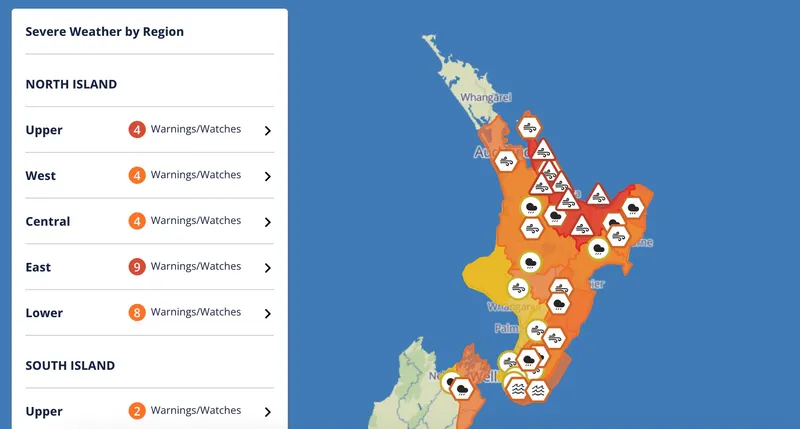
The Northland region is no longer under a severe weather warning as Cyclone Vaianu makes landfall further south, but residents in Whangārei have been warned to still take care with continued gusts.
The rest of the North Island remains blanketed in weather warnings, with the Bay of Plenty currently under severe wind and rain warnings. Residents are advised to avoid floodwaters and shelter in place if they have not be able to evacuate safely yet.
Northland and Auckland avoid the worst
The memory of the Auckland Anniversary weekend floods of 2023 would’ve been fresh in mayor Wayne Brown’s mind as he spoke to media earlier today. Auckland and Northland escaped the worst of Cyclone Vaianu this morning, with civil defence centres set up across Auckland in preparation of severe flooding. Instead, the cyclone tracked further east than expected and, as of 3.30pm, the emergency centres plan to close by tonight.
Brown said the impacts were not as bad as expected “and that’s a good thing. It doesn’t need to be bad to prove you were correct,” he said. Meanwhile, Northland’s severe wind warning has lapsed, the rain has stopped and there’s clear blue sky visible.
Power outages continue to impact more than 2,000 homes
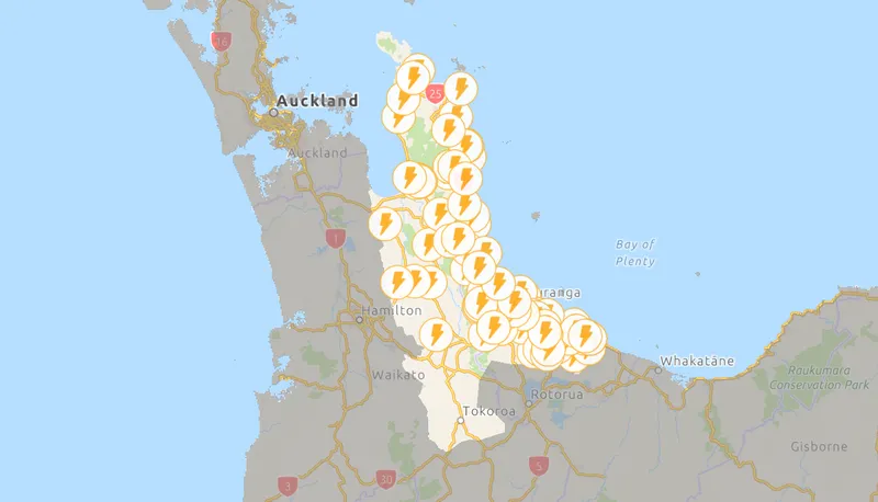
The latest updates on power outages, largely centred in Coromandel and Bay of Plenty, shows 2,309 homes without electricity. These are unplanned outages, coming as Cyclone Vaianu made landfall earlier this afternoon, downing trees and power lines in the region. Outages can be viewed and reported here.
All eyes on Hawke’s Bay as emergency centres close in Bay of Plenty
Emergency centres in Tauranga will close shortly as ex-cyclone Vaianu continues its path, having wrought less havoc than feared in the Bay of Plenty. Similarly, Western Bay of Plenty District Council recovery manager Jo Lynskey said the council would be looking to close community hubs as few people sought assistance there – about 60 people sheltered in marae across the district.
Rotorua Lakes Council closed its welfare centre as nobody had required assistance there. Instead, fire and emergency services have sent resource east to Hawke’s Bay where the ex-cyclone is expected to exit the country tonight. The worst of the weather has yet to hit there, with more than one windsurfer “enjoying” the wind and waves off the coast of Napier this afternoon. Residents are being urged to stay away from the water and shelter indoors.
What to expect tomorrow
Today is all wind and rain for much of the North Island, and Metservice is forecasting continued showers tomorrow as the last of Vaianu passes through. But there are a few bright spots (both sun and lightning).
Northland
Showers return tomorrow, possible thunderstorms in the afternoon and evening.
Auckland to Taranaki, including Coromandel, Bay of Plenty and the central high country
Showers becoming heavy and widespread again for a time tomorrow, with thunderstorms possible.
Gisborne to Wairarapa
Partly cloudy tomorrow, with a period of rain in the afternoon or evening. Severe gale easterlies turning severe gale westerly today, then easing overnight.
Whanganui to Wellington, also Nelson, Buller and Grey
Periods of rain or drizzle, heavy at times. Thunderstorms possible from tomorrow afternoon.
Marlborough and Canterbury
Partly cloudy tomorrow.
Westland and Fiordland
Showers, frequent and heavier tomorrow with possible thunderstorms.
Otago and Southland
Possible thunderstorms in eastern Otago tomorrow.
Chatham Islands
Fine spells, rain tomorrow morning.
Whakatāne evacuated residents urged to stay put
Whakatāne council and police officials have provided an update to residents following the worst of the ex-cyclone weather. Trees have fallen, blocking roads and closing off the town. Those who evacuated have been asked to stay where they are and not attempt to return to their homes until advised by authorities that it is safe to do so. Inspector Phil Gillbanks also urged residents to “only travel when absolutely necessary” to allow contractors in to clean up the mess on the closed roads.
Centre of Cyclone Vaianu officially exits New Zealand but wild weather to continue
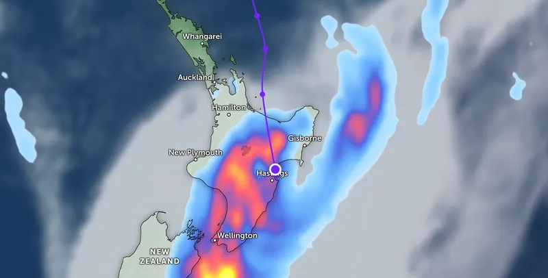
The Zoom Earth live weather map indicates that as of 5.30pm, the eye of ex tropical cyclone Vaianu is no longer on land. The image, captured at 5.34pm, shows the cyclone drifting off the east coast just north of Napier. Hawke’s Bay is currently under an orange wind warning and a heavy rain watch.
Heavy rain and strong winds are forecast for the rest of the evening and overnight in much of the east coast and Coromandel. Residents who evacuated their homes have been urged to stay away until tomorrow as weather could turn overnight.
Madeleine Chapman
Madeleine Chapman is a contributing editor. She was editor of The Spinoff 2022-2025.


