The first step in recloaking Aotearoa’s native ecosystems is knowing what used to be there.
This is an excerpt from our weekly environmental newsletter Future Proof, brought to you by AMP. Sign up here.
Imagine you arrive in Aotearoa before any other humans. What sort of landscapes would you encounter? Canterbury lowlands swathed with forests of mātai, kahikatea, and tōtara. Rolling dunelands along the west coast of the North Island. Rich swamplands in valley floors and around river deltas.
Significant chunks of these ecosystems have gone, cleared to make way for the places we live and grow food. But if we can restore them to even 15% of their former extent, research suggests, we could do a great deal of good for our native biodiversity.
“When your native ecosystem land cover drops below about 15%, that’s when a lot of species go into freefall because they just don’t have the resources. They don’t have the home that they need to survive as a species,” says Kiri Joy Wallace, co-lead of the Eco-index programme. “Nationwide progress toward the 15% native ecosystem landcover goal will give us a good chance of bringing many native birds, reptiles, bats, plants and insects back from the brink of extinction.”
The Eco-index team, under the umbrella of the New Zealand’s Biological Heritage National Science Challenge, has crafted a vision to restore each ecosystem in a given catchment to 15% of its natural range by 2121, a “nice, long 100-year runway to work step by step, year by year to restore and get ourselves back to a healthy state,” says Wallace.
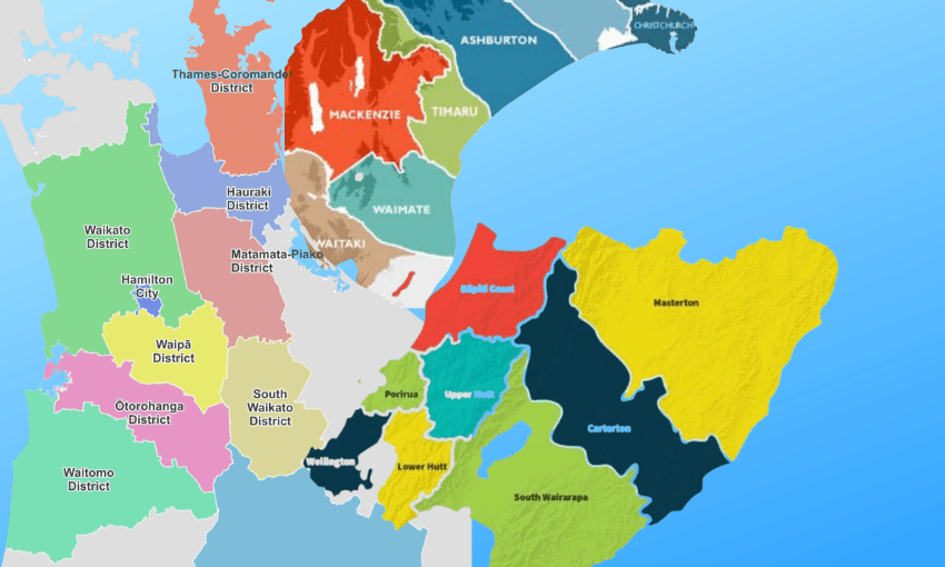
A new interactive map provides the first step on that journey, laying out what ecosystem types – forests, marshes, swamps and so on – cloaked the country before humans arrived. This is overlaid with areas where the ecosystem cover has dropped below that 15% threshold and needs a boost. Land managers can explore what ecosystem types remain on their patch, as well as which ones are missing.

In some catchments, native ecosystem cover has dropped very low. For example, swamps in Tukituki cover 1.29% of where you’d expect to find them and mātai-kahikatea-tōtara forest in the Ashburton-Hinds catchment covers just 0.54% of its expected natural range. Wallace notes that those brightly coloured ecosystem types can’t be offset by the other types that are faring better, like beech forest, since different ecosystems are home to unique assemblages of plants and animals.
Zooming out for a whole-country view, the eastern South Island and large tracts of the North Island glow pink and orange in this second layer, signalling areas of loss but also of potential. “This is a great opportunity to see where we could do better,” says Wallace. “And we can celebrate where we’re doing well already, and protect and look after those places so they don’t slip into that very bright pink.”
Further map layers show marae locations, regional council boundaries, community groups and biodiversity stories. These aim to “encourage people to see this as a team effort,” says Wallace. “We have designed it to be like a choose your own adventure story. It is a lot of work, but we can learn a lot and make the most progress working together.”
Future updates to the map aim to incorporate satellite data with ecosystem types identified by AI, so we can collectively monitor our progress towards that 15% goal.